Monday, November 7, 2011

Stand by for offload. Stand by for science. Standing by.

While working in Antarctica has an immense number of benefits (interesting science, beautiful scenery, great people to sail with on the boat), it does have one major drawback – which is the weather.  Our first task on this trip was to offload a team of fur seal and penguin researchers (led by Dr. Mike Goebel, from the Southwest Fisheries Science Center which is part of NOAA) at their field camp on Livingston Island. They'll spend the next 4 to 5 months conducting research there and the data the collect is extremely valuable as they've been studying the animal populations here for more than two decades. Time series like that can be very valuable in answering questions related to how the ecosystem here reacts to the changing environmental conditions so making sure we get their camp set up and ready to go for this year's work is an important job for us.

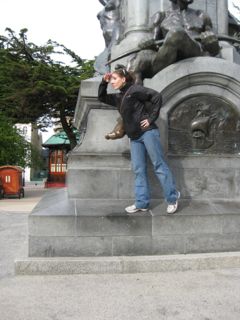
The field camp at Cape Shirreff as seen from the deck of our ship. The green buildings are the US field camp, while the white buildings are a Chilean field camp which will open a little bit later this year.

The Laurence M. Gould (our vessel) has to stage about a mile away from the camp due to a lot of varying bathymetry near the camp landing. Thus the researchers and all their supplies (equipment, food, etc) are transported by zodiacs (inflatable rubber boats about 20' long). Opening the camp is a long process (around 6 hours or so) involving everybody on the boat (whether its carrying gear from the beach to the camp, shoveling snow, holding the boat in the surf zone at the beach) and more than a dozen back-n-forth trips by the zodiac.  Obviously, we need a nice weather window in order to accomplish this and unfortunately we haven't had that yet since we got here late in the evening on Nov 5th.

The weather report for the evening of 06 Nov. Windy!

We spent yesterday in stand by mode waiting for the weather to improve, but by the middle of the afternoon, the conditions had actually gotten worse. We had sustained 50 kt winds, the seas were quite large, and as Mike Goebel (who's worked at this camp for 21 field seasons) said “once the seas get spun up like this, they stay up for a while.”  So the scientists on board met with our Chief Scientist (Ann Bucklin) and came up with a plan. We'd steam south and try to occupy one of our interior stations (which might be a bit more sheltered) and see if conditions were better as Station 22 is in a bit of lee from some islands at the northern end of the Gerlache Strait.  Several of us got up around 530am this morning, went up to the bridge and met with the Captain and our Marine Projects Coordinator (Jullie) to discuss whether we would be able to do any science here.  The seas were still pretty good size, but the wind was blowing a steady 30 kts which would mean if we tried to launch (and recover) our net systems, there's a good chance we'd tear or lose them.  While we carry spares of most of our systems on board the vessel, there's no benefit to risking equipment this early in the cruise.

That land you see is the Antarctic continent !  The Gerlache Strait is a body of water that lies between the continent and several islands just off shore.  If the weather is nice, this trip can be one of the most beautiful sights one can see in Antarctica. However, today it's mostly overcast, foggy, and rainy/snowy.  Oh yeah, The air temperature is -1 C with a wind chill of ~ -20 C

So we are now heading to Palmer Station (originally our 2nd stop on this trip) to offload several people who are working at the station for the duration of our cruise (or longer).  We'll be there for a full day as there is a lot of cargo that needs to be moved on and off the ship. We'll attempt to calibrate our acoustic systems (if the weather is decent) and set off in another day to head back up north towards Livingston Island and start doing science.

And what about Mike Goebel and his field team (Keven, McKenzie, Jay, Nicole) ?  They are stuck aboard the ship until we can find a weather window where we can put them into their field camp. Hopefully after Palmer Station, we'll be able to drop them off and move their gear in better conditions. But in the meantime, they have all been deputized as Assistant Salp Scientists and may give us a hand with some of our sampling until we get them where they are supposed to be.


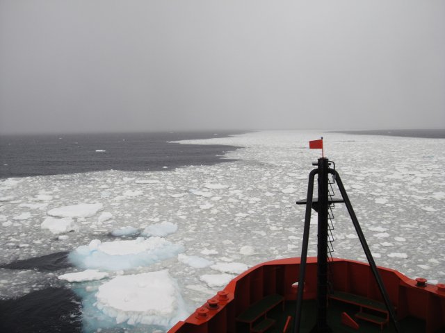
The bow of the Laurence M. Gould as it cuts through a field of brash ice. This ice isn't very thick but the mates do have to keep an ice out for larger pieces of ice (bergy bits, growlers, small bergs) and steer around them if possible. Sometimes this is easy and the ice clears out quickly.
We're currently steaming through the Gerlache Strait towards Palmer Station and the weather continues to be a mix of sun and fog and rain and snow.  We hit our first stretch of brash ice this morning (we've seen a couple of icebergs so far but most have been far off) which means the new people on this trip will have several hundred pictures from this morning.

Keep your fingers crossed for some better seas and winds for us!


Joe

Sunday, November 6, 2011

C is for Chocolate Chip Cookies!!!!!

Yesterday we were unable to unload at Cape Shirreff due to sustained 30 knot winds and 8 to 12 foot seas.  We will be trying again today, but yesterday there was not much to do except…EAT COOKIES.

You might be wondering why we keep mention these cookies and what’s so special about them.  We wish we could send a cookie through the screen to share them with you, but unfortunately that technology hasn’t quite been developed yet.  We’ll work on it.

Every morning, around lunchtime, the Chief Steward, Rameses, puts out a fresh bucket of chocolate chip cookies.  The best time to eat them is right after lunch, when they are still warm.  The chocolate chips are still melty; the dough is crispy on the outside; the inside is gooey – A little slice of heaven.   They are also delicious any time of the day; we find it extremely difficult to walk by the cookie bin without reaching for yet another cookie.  We asked Rameses what the secret ingredient was.  We were hoping it was love, but we think it’s probably lard.

 Thumbs up for chocolate chip cookies!!!!
We are currently working on building up our insulation layers, but our plan once we start scientific stations is to be constantly engaging our abdominal muscles while processing samples.  And do squats while filtering chlorophyll.  Melissa P. plans on doing lunges while flying the MOCNESS (Multiple Opening and Closing Environmental Sampling System) – Don’t tell Peter!  :)  So don’t worry, friends and family, we won’t need gym memberships for Christmas.  We’ll be in ship-shape in no time (pun intended)!

The question remains:  “Who stole the cookie from the cookie jar?”

  The Answer is, probably one of us… L:R – Little Melissa, Chelsea, Melissa P. and Katie.  We all love cookies!!!
Hope you’re having a great weekend!

-Katie, Chelsea, Melissa P., and Little Melissa

Saturday, November 5, 2011

05 November - Rollin’ With My Homies

Today we continue our journey across the Drake Passage to Cape Shirreff and we are finally feeling like we are in the Drake!

Before leaving Punta Arenas, Chile, we all ventured to the statue in the town square of the great explorer Magellan.  Legend has it, if you rub the statue’s toe you will have good luck on the crossing.
Magellans_toe.jpg.  caption:  Melissa P. imitating the great explorer Magellan as he navigated the waters later known as the Straits of Magellan.  Note the gold tip on his toe from being rubbed for good luck on the crossing of the Drake Passage by so many sailors before us.

Well, it must have worked, because we are having a VERY nice crossing (compared to what I was expecting).  But even with “nice” conditions, the winds are a sustained 20 knots and we have been experiencing 8-15’ swells.  There have been a few casualties of equipment and chairs (I TOLD you to tie that down!) but so far, all science party members have walked away with nothing more than a few bruises (although the swells do make working at your computer or moving around the ship rather treacherous).

Melissa M. holds on tight (and fights back laughter) as a 15’ swell rocks the boat and knocks her chair right out from under her.
And most people appear to have medicated well because everyone was at dinner last night, even if for only a short period.  I would call this a successful crossing indeed!

During our downtime from our own science mission, we have been helping fellow scientists collect data on our crossing of the Drake Passage.  We have been doing XBTs (eXpendable BathyThermographs), XCTDs (eXpendable Conductivity-Temperature-Depth sensors) and collecting water in order to make measurements about the temperature and salinity of the water we are traveling through.

 Katie demonstrates how fun it can be to deploy the XBTs (this picture was taken after her 3rd chocolate chip cookie of the day…more on these in a later blog).

This information gets sent to various scientists around the world and also gets posted on an international database, to be shared by all.  We are a part of something big by helping others collect data in the passage!

If all goes as planned, we will complete our crossing of the Drake Passage sometime this morning and arrive at Cape Shirreff around noon (local time).  Once there, we will offload the crew that will be doing fieldwork on penguins and seals on the island for the next four months, along with all their supplies.  It will take several hours to offload all their equipment and “freshies” (fresh fruit, vegetables, milk and other perishables) and they will need everyone’s help to get through the task as quickly and efficiently as possible.  I have been tasked as a “Sherpa,” which apparently means they will drop me off on the island and I will be lugging cargo from the zodiacs (small inflatable boats) to the field camp on large sleds across the snow…I am picturing something like the Iditarod, but with me as the sled dog!

Well, it’s time for our All Hands meeting about our busy day at Cape Shirreff, so I’ll wrap this up for now.  Wish me luck in my Sherpa adventures!

Melissa P.

04 Nov 2011 – Special Blog post for students in MAR 353 (and anybody else who's interested)


I thought I'd give the students in my Physical Oceanography Laboratory Course a little extra credit assignment to do before next week's lab. Answers can be submitted on hard copy or via blackboard, but are due before the start of lab next thursday (Nov 10th).

On the boat we get a couple different kinds of weather and satellite maps which we use to help us try to understand what the weather will be like during our trip. We also get a daily forecast sent to us for the general area by the Navy which is very handy and supplements the following maps.

Ice Coverage
This is a satellite image of ice cover from 01 Nov 2011.

Satellite maps of ice coverage are useful for us to determine how likely we will be to open the field camp and drop off the penguin and pinniped researchers.  Land masses are filled in in blue. Ice coverage can be seen although in some cases it is difficult to determine what is ice vs. cloud cover vs. other reflectances in the images. Ice bergs appear as small (at this images scale) white dots/specks.

There are many different stages of ice (brash, grease, frazil, pancake, fast, first year, second year, etc) and these images often can't distinguish those types from one another. Our last night in Punta Arenas, we ate dinner next to a group of pilots from NASA who are flying radar and other instrumentation aerial surveys of ice cover and thickness on Antarctica (mostly ice on land, not sea ice). Their instruments can measure ice thickness, heat content, or other data types that help us to understand the movement of heat in this region.

Barometric Pressure Maps

We get model simulations from two different sources and despite the differences in technology (computer models vs. hand drawn isobars), they generally provide similar predictions of our weather.

 This is a combination visible satellite and barometric pressure map (green lines) for today.
The Chilean Navy's maps relay on hand drawn isobars and contours. You can see from the map, they welcome reports of current conditions to help their forecasts as there are very few weather stations in this area to provide input data into predictive models.

Underway Meteorological Observations
: The ship has monitors in most labs (and state rooms) that display the current meteorological conditions. This (as well as deck cameras) is very useful information to have when getting ready for deck work on the ship as you have some idea of what it's like outside before you actually go outside. I've blacked out the wind speed and direction information in this image, but you can look at what the current air and sea surface temperatures are right now.
Questions for students

1. What is your prediction (based on the satellite image above) for the level and type of ice we'll encounter tomorrow when we get to the camp. We will be anchoring the boat NE of the Cape Shireff peninsula about 1.5 km from land. Provide an estimate of % of surface covered by ice and thickness (in cm) of the ice that we might find (guessing open water / no ice is also an option).

2. What would the presence of a 10 cm thick layer of ice over the surface of the water around this island mean in terms of the temperature and salinity profiles here ?  That is, draw T and S vertical profiles for a spot just off of Cape Shireff (assume water depth is 200 m) for early austral spring (November) for the region with and without a layer of ice.

       3. Our ship is currently located at 59.5 S and 62.5 W.  Using the two above maps (and no other resources), provide a prediction of the following for today: wind direction (remember we're in the southern hemisphere) and rough guess at the speed and % cloud cover. And for tomorrow (05 Nov – noon – you can assume all times on the maps and for predictions are GMT), predict what the wind speed (qualitatively) and direction will be at Cape Shireff (roughly located at 62 S, 62 W). Provide an explanation for what your predictions are.

4. From the meteorological plot, do you think we are on the North or South side of the polar front (i.e. Antarctic Circumpolar Current) ? Provide an explanation of why you picked which side.

Are we there yet?

Well, we’re still chugging along toward Cape Shirreff [on Livingston Island] and Palmer Station. Still a day to go before we get to Shirreff. There isn’t much to do except wait at this point, and try not to roll out of bed at night with the waves that started picking up more last night.

So here’s a tid-bit about life on the Gould for everyone reading. In case you didn’t know, the handles on the toilets aren’t like normal flush handles. They’re more like valves that you have to hold open while the toilet flushes, and if there’s one thing that I’ll remember about being on the Gould it’s that when you’re done on the toilet, MAKE SURE THE VALVE IS SHUT!  They drill that one into your head from day one. You see, when the valve doesn’t close all the way, the water just keeps running and messes with the ship’s plumbing, so they have to turn the water OFF and barge into every bathroom on the ship until they find the source and close it, which isn’t fun for anyone.  So remember kids, when you gotta go on the Gould, make sure to close the valve!
: Every toilet has a sign next to the valve as a reminder, so there isn’t much of an excuse for forgetting, but people still do!

Melissa M

Entering the Drake: Birds, birds, birds!


It will take about four days for the ship to get from Punta Arenas, Chile, to Cape Sheriff, where we can start our zooplankton studies. Until then, all of the lab equipment is either put away or securely tied down so it doesn’t go flying around the lab when it starts to get rough.   We have been working with the other salp team to get protocols and data sheets nailed down, eating lots of chocolate chip cookies, and doing lots of bird watching!

Melissa M. on the look out for birds, with dramatic topography in the background.

This afternoon, I spent a bit of time out on deck with both of the Melissa’s.  We were just passing the Islas de Estados  which provided a beautiful backdrop.  We saw Pintado Petrels,  Black-browed Albatross, Giant Petrels, Terns, and more.  Here are some photos to help you share the experience:


 Pintado Petrel, also known as a Cape or Painted Petrel.  Looks like someone finger painted him!

 Black-browed Albatross.  Their wingspan can be up to 250cm!  They feed mostly on fish and krill.


That’s all for today!  This afternoon we will be starting XBT deployment survey of the Drake Passage.  More about that tomorrow!

Katie

Wednesday, November 2, 2011

02 Nov 2011 - And we're off ! [or “She's a puker”]

Our trip has begun! A nice view of a part of Punta Arenas, Chile as we begin our journey south.

We left the dock in Punta Arenas just before noon today (local time in PA and on the ship is one hour ahead of the US East coast) and have just left the somewhat protected waters of the Straits and are beginning our journey south hugging the eastern coast of Patagonia as we head towards Cape Horn and start our journey to Antarctica.
 Sustained 30 kt winds can create a lot of surface chop and spray, but the straits are narrow enough that the waves can't grow very large so it was a gentle ride. Let's hope that continues.

The weather when we left was quite nice, very clear and sunny; although it did get a little breezy (30-35 kt winds with gusts up to 50 kts) this afternoon.  We've spent the past 2 days unpacking all our equipment, setting up lots of our gear, and then tieing everything down securely to make sure it doesn't fall or break during the Drake Passage crossing [the Drake Passage is the area between South America and the Antarctic Peninsula].
 
Everybody gets a chance to put on their survival suit as part of the safety orientation. We sometimes call these “Gumby suits” as you are not too capable of fine-scale movements or motor control once you've got it on. These suits are designed to not only provide floatation for us if we went into the water, but they also provide protection from the cold (although we hope we never have to use them). 

Today we had several meetings going over safety procedures in case of an emergency (knock on wood); deck orientation; science lab orientation; and the consumption of several chocolate chip cookies (ok, that wasn't really a meeting). The Chief Mate (Scott) during our safety orientation described our ship (the Laurence M. Gould) as “she's a puker” so I think most people are a little wary of how bumpy the next few days are going to be.

This trip's purpose is to have the science groups aboard collect data about salps, which are a very unique creature that most people have probably never seen, but is probably going to play an increasingly important role in the Antarctic ecosystem (that's part of our hypothesis-- we'll see if our data support this). We'll try to post a new blog entry roughly once a day – although that depends on the conditions and our science schedule. If  you have questions for us, please post them in the comments or email them to ales.lab.sbu@gmail.com and we'll try our best to answer them.

We had a all-hands meeting after dinner tonight where each of the science groups on the boat (including some that are just riding down with us to their field site where they will spend the next 4-5 months!) gave brief overviews of the scientific questions and methods that we're going to be working on. It was a really interesting discussion as each group is studying a different aspect of the ocean ecosystem, but the one theme that was present in all our talks is that the Antarctic Peninsula is a region that is experiencing a lot of change both physically (i.e. temperature) but also ecologically (decreases in some animal populations, increases in other animal populations, geographic shifts in where you find these organisms).  Antarctica is a beautiful place to work, but the real draw (for me at least) is that the scientific questions are so interesting here.
What a better place for a photo of our field team this year! Katie (left side, green hat), Melissa P. (right side, nearest), and Melissa M. (right side, next to the other Melissa) enjoy the luxurious comforts of the ship's life raft which we got into as part of the safety orientation.

We'll have more on this later, but our team from Stony Brook this year includes: Katie W.(a recent graduate of Cornell University), Melissa M. (a recent graduate of Stony Brook University), and Melissa P. (a 2nd year graduate student in my research lab). Katie W. and Melissa M. were part of the field team here last year, but this is Melissa P.'s first trip to the Southern Ocean.  We'll be taking turns posting to the blog so you'll get to hear from all of us over the next month.
 Our first day at sea ended with a really lovely sunset as start our trip to Antarctica. Hopefully there'll be a lot more pictures like this during the next month while we are at sea.

Sorry this is short, but it's late here and the boat is starting to move around a bit. A common reaction of our bodies to the motion of the sea (and ship) is to become sleepy. So it's time to hit the rack.

- Joe